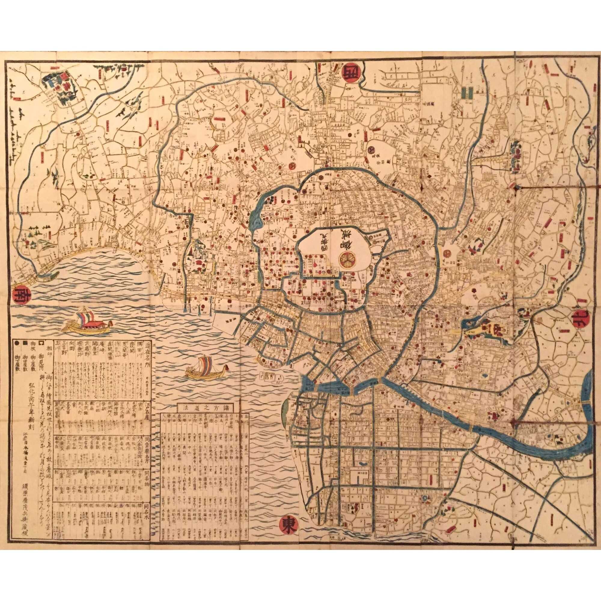
Title: Map of Edo (江戸之図, Edo no zu)
Cartographer: Unidentified
Publisher: Unidentified
Date: 1849 (Kaei 2)
Format: Woodblock-printed map; ink and color on paper; folding
Dimensions: 86.3 x106.6 cm (34 x 42 in)
Orientation: North at top (non-standard orientation; cardinal points marked in red seals at margins: 東 = east, 西 = west, 南 = south, 北 = north)
Description:
Detailed woodblock map of the city of Edo (modern Tokyo), centered on Edo Castle (江戸城) and surrounded by daimyō residences, samurai quarters, temples, and waterways. Districts are labeled in black kanji, and major landmarks are color-coded. The Sumida River (隅田川) and surrounding moats are delineated in blue, while the coastline of Edo Bay features two decorative sailing ships. Red seals at the four corners indicate cardinal directions.
The lower-left section has a boxed legend (凡例, hanrei) and a detailed index in vertical script, listing place names and administrative divisions. The castle precincts are marked with the Tokugawa mon (triple hollyhock crest), and important temples and shrines are highlighted throughout.
The map appears designed for practical use and aesthetic appreciation, combining cartographic precision with Edo-period decorative sensibilities.
This 1849 map of Edo (modern-day Tokyo) reflects the urban geography of the Tokugawa period, with Edo Castle prominently at the center and city districts organized in a radiating structure. Such maps served both practical and representational purposes and were often folded for portability. Decorative motifs—such as stylized ships and waves—are common in this genre.
Geographicus: In recent decades, the digitization of historical Japanese maps has raised complex issues surrounding the visibility of locations associated with the Burakumin, a historically marginalized social group. Certain maps from the Edo and early Meiji periods, including those held in Japanese and international collections, occasionally include references to areas identified with occupations considered "unclean" under the premodern caste system. Although Japan officially abolished this caste structure in 1871, concerns have been raised about the ethical implications of reproducing such maps online, particularly in geographic search platforms, where they may inadvertently contribute to social stigma.
Additional Information
| Collection | Japan: art, history, literature |
|---|---|
| Type / Purpose | Map |
| Period | 19 AD , Edo period [江戸時代] (1603–1868) , Kaei era [嘉永] (1848–1854) , Mid-19th century |
| Country | Japan |
| Media/Technique | Colour , Ink , Paper , Woodblock print |
| Subject | Early maps , Geography , History , Japan , Japanese history , Tokyo |
| Creation / Publishing year | 1849 , Kaei 2 |
| Location | BOX JB-01 |
| Acquisition year | 2025 |


