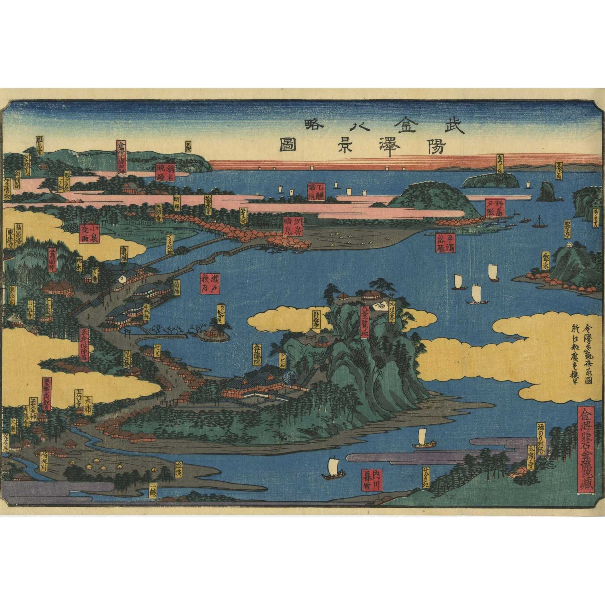
Utagawa Hiroshige. Rough Map of the Eight Views of Kanazawa in Musashi Province, with the original pouch / Dai Ōban, 1851.
Publisher
$12,000
For Sale
$12,000
For Sale
Title: The Eight Views of Kanazawa in Musashi Province (武陽金澤八景略圖, Buyō Kanazawa Hakkei Ryakuzu)
Artist: Utagawa Hiroshige [歌川広重] (Japanese, 1797–1858), also known as Andō Hiroshige [安藤広重]
Signed: 於江都廣重摸写 (Tōto ni oite Hiroshige mosha, “Reproduced by Hiroshige in Edo”)
Publisher: Unknown
Date: 1851 (Kaei 4)
Media: Woodblock print (nishiki-e); ink and color on paper; Dai-ōban; 45.8 × 34.4 cm
Genre: Landscape / Meisho-e (名所絵)
Title on print: 武陽金澤八景略圖 (Buyō Kanazawa Hakkei Ryakuzu, Rough Map of the Eight Views of Kanazawa in Musashi Province)
Title on pouch: 金澤八景止圖 (Kanazawa Hakkei no Zu, The Eight Views of Kanazawa)
Inscription on pouch (yellow cartouche): 金沢飛石 金龍院蔵 (Kanazawa Tobiishi Kinryū’in zō, “Owned by Kinryū’in Temple [home of the] Kanazawa Flying Stone”)
Publisher’s imprint (pouch reverse): 河邉富三郎 (Kawabe Tomisaburō) from 三島大社町 (Taisha district of Kawashima)
This panoramic map presents a rich bird’s-eye overview of the celebrated Eight Views of Kanazawa (金澤八景) in what was then Musashi Province (modern-day Yokohama, Kanagawa Prefecture). Rendered with Hiroshige’s signature clarity and dynamic composition, the print captures a scenic coastal landscape populated with temples, shrines, pavilions, and labeled topographic features.
Large red and yellow cartouches identify notable locations, including:
The landscape is densely annotated with temples, residences, waterways, and small ports. These include:
Sailing boats dot the inlet waters, and bridges link small islands and shores. The layout is spatially condensed but readable, serving as an artistic souvenir and a geographic guide for Edo-period travelers.
Excellent condition, extremely rare.
References: (1) JAANUS; (2) Kanazawa Hakkei
| Collection | Japanese prints and drawings |
|---|---|
| Type / Purpose | Map , Woodblock print |
| Period | 19 AD , Edo period [江戸時代] (1603–1868) , Kaei era [嘉永] (1848–1854) , Mid-19th century |
| Country | Japan |
| Media/Technique | Ink and color on paper , Woodblock print (nishiki-e) |
| Size | Dai Oban |
| Subject | Bushū / Musashi Province [武州 / 武蔵国] , Early maps , Japan , Japanese woodblock prints , Kanazawa (Japan) , Maps , Physical maps , Views |
| School | Utagawa (歌川) |
| Creation / Publishing year | 1851 , Kaei 4 |
| Acquisition year | 2019 |