-
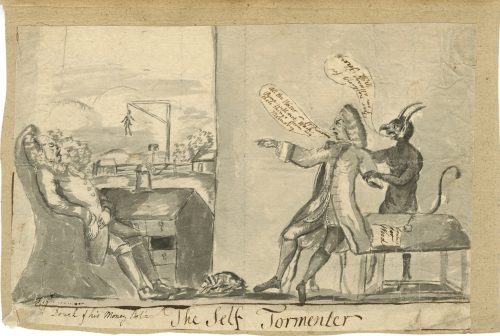 Ink drawing on watermarked paper by an anonymous artist, British or American. Original pen and ink with manuscript text. About 7 x 10⁻¹/2 inches, Vander Ley type watermark (Churchill 321), mounted to old laid paper; several corners chipped, some creasing, soiling, etc. Np, Late 18th-century.
 -
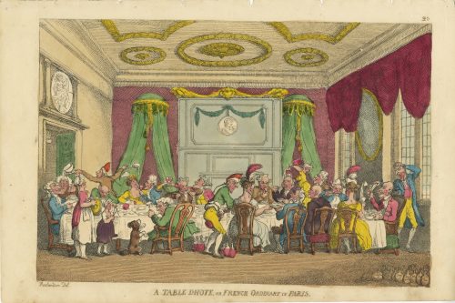 Hand-coloured etching by Thomas Rowlandson, printed on May 30, 1810, in London; № 20 from the series The Caricature Magazine or Hudibrastic Mirror Vol. 2. Description by Metropolitan Museum (59.533.978): "Guests of a dinner sit at a long narrow table in a magnificent room with an ornate ceiling. Two men and a young woman serve wine, one drawing a cork, the others spilling wine over the guests. Another waiter spills soup in an elderly guest's face. A woman and a little girl with a begging dog play tambourine and triangle at left." Inscribed in plate lower left: "Rowlandson Del."; bottom centre: "A TABLE DHOTE, OR FRENCH ORDINARY IN PARIS." Our copy is lacking the publication details: "Pub.d May 30. 1810 by Tho.s Tegg 111 Cheapside, London." and similar to the copy in Boston Public Library (18_03_000394). Dimensions: Sheet 27 x 40.5 cm; Image: 23.5 x 35 cm. Contributors: Thomas Rowlandson (British, 1756 – 1827) – artist. Thomas Tegg (British, 1776 – 1846) – publisher.
 -
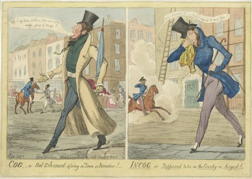 Description by British Museum (1865,1111.2128): "Two designs, side by side. [1] A dandy (probably a portrait), florid, whiskered, and bearded, steps jauntily from the pavement, hand extended, saying: Ah! my dear fellow — How are you? Devilish glad to see ye!— He holds a closed umbrella, ferrule erect, and wears a long tight-waisted coat to the heels, unbuttoned, tight pantaloons and spurred boots. In the middle distance, another dandy grasps the hand of a friend on horseback. Behind are houses with shop-fronts. A man raises his hat to a lady who curtseys. [2] The same dandy steps from the roadway onto the pavement, his handkerchief to his nose; he stoops, trying to conceal himself from a dandy cantering past in a cloud of dust, his eye-glass to his eye. He is without gloves, extraordinary for a dandy, and his trousers are strapped over pumps; he says: Con-found it! — Didn't expect to meet Him!! The street is otherwise empty; against the (large) houses are scaffolding and a tall ladder." Lettered with title, text within image including production details: 'Ego. delt / Etched by G. Ck / Pubd by J Fairburn Broadway Ludgate Hill August 18 1826'. Dimensions: Sheet: 25.5 x 36 cm, Image: 21.7 x 33.8 cm. Catalogue raisonné: A. M. Cohn (1924): № 1001, p. 262.: "A wretched plate. Difficult to believe G. C. had anything to do with it." — Bruton. Value.— £1.
 -
 One of 64 wood engravings by Robert Dill after Joseph Kuhn-Régnier (French, 1873 – 1940), stencil-coloured (au pochoir technique) by Ateliers Jacomet in Paris for the 4-volume edition of Littré’s “Œuvres complètes d'Hippocrate” by Javal & Bourdeaux in 1932-34. The edition was limited to 2,335 numbered copies, 2,000 of them on Vélin teinté du Marais paper., numbered from 336 to 2,335. Contributors: Joseph Kuhn-Régnier (French, 1873 – 1940) – artist. Robert Dill – engraver. Atelier Jacomet (Paris); Daniel Jacomet (French, 1894 – 1966) – printer. Les éditions Javal & Bourdeaux (Paris) – publisher. Émile Littré (French, 1801 – 1881) – translator/ editor. Hippocrates (Greek, c. 460 – c. 370 BC) – author.
 -
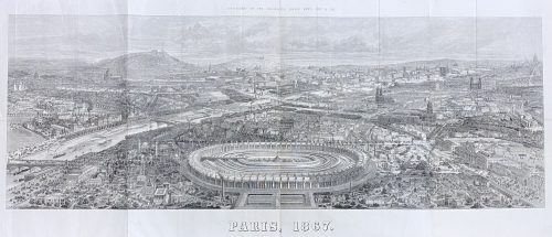
Lithography on paper by Charles Fichot (French, 1817 – 1903), published in a supplement to the Illustrated London News of July 6, 1867.
The construction on the foreground is the International Exposition of 1867 (Exposition universelle d'art et d'industrie de 1867). Dimensions: Sheet: 130 x 58 cm; Image: 118 x 43 cm. -
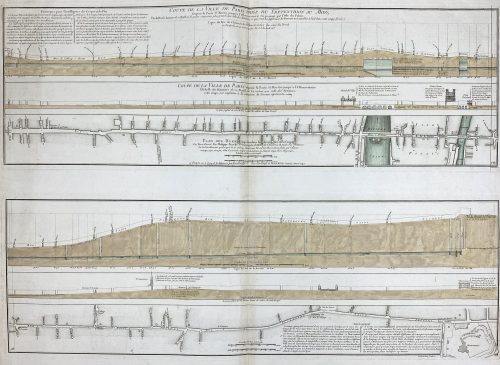
Two prints on one sheet of watermarked laid paper.
Coupe de la ville de Paris prise du septentrion au midy, depuis la porte St Martin jusqu'à l'Observatoire en passant par l'isle du Palais... Coupe de la ville de Paris depuis la porte St Martin jusqu'à l'Observatoire... Plan des rues comprises dans la direction dela coupe... / Le tout dressé par Philippe Buache... ; Desbruslins, sculpsit.
Watermark: "IHS" within circle; countermark of "FIN/ DUPUY/ AUVERGNE 1749".
LOC dates it to 1757. Gallica – to 1742, though the watermark is 1749.
-
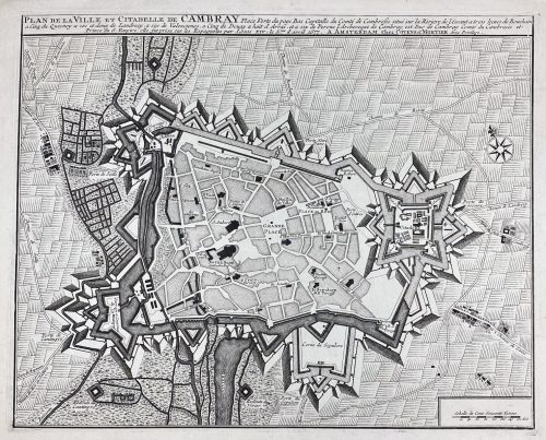
Plan de la ville et citadelle de Cambray : place forte du pays bas capitalle du Comté Cambresis situé sur la riviere de l'Escaut a trois lieues de Bouchain, a cinq du Quesnoy, a six et demy de Landrecy, a six de Valenciene, a cinq de Douay, a huit d'Arras, et a six de Perone, l'Archeveque de Cambray est Duc de Cambray, Comté du Cambresis et Prince du S. Empire, elle fut prix sur les espagnoles par Louis XIV, le 5.me d'April 1677; A AMSTERDAM Chez Covens & Mortier, Avec Privilege.
Date of publication: [between 1721 and 1778].
Dimensions: Sheet: 48 x 58.3 cm; Image: 38.2 x 47.7 cm. Earlier editions of the same were by Pierre Husson in the Hague (ca. 1715) and by Eugene Henry Fricx in Brussels (1710). -
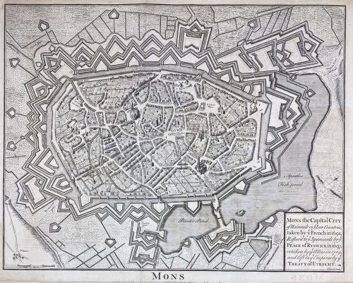
Mons the Capital City of Hainault in y Low Countries, taken by y French in 1691, Restor'd to y Spaniards by y Peace of Ryswick in 1697, retaken by y Allies in 1709, and left to y Emperor by y Treaty of Utrecht. attribution to publication source has been trimmed.
Dimensions: Sheet: 40.7 x 52.5 cm; Image: 37.5 x 48 cm. Published between 1744 and 1747. Attribution to publication source has been trimmed. Reference: Royal Academy 03/2919. Source: Maps for Mr. Tindal's Continuation of Mr. Rapin's History of England. London: John and Paul Knapton. Nicolas Tindal (British, 1687 – 1774) – the translator and continuer of the History of England by Paul de Rapin. Paul de Rapin (French, 1661 – 1725) – a Huguenot historian, author of the History of England. -
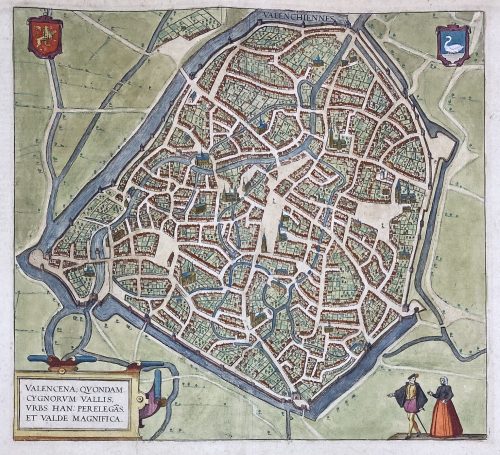 VALENCENA, QUONDAM | CYGNORUM VALLIS | URBS HAN: PERELEGÃS | ET VALDE MAGNIFICA. ||
Engraved and hand-coloured map of Valenciennes first produced for Braun & Hogenberg's 6-volume Civitates orbis terrarum edition in 1570.
English translation of the text printed on verso: "The Loire, an exceedingly well-known river in France, flows directly past the city and is very beneficial for trade. The fields surrounding the city are very fertile, and for this reason, the city is also called the granary throughout France, just as in earlier times Sicily was the granary of Rome. A famous wine also grows in this soil, which is exported from here not only throughout France but to all the countries in Europe. [...] The French spoken here is pure and uncorrupted, which is also the reason why so many foreigners settle here. For some are here for trade, others for study and others again to acquire the language, but also many without doubt for both these last two reasons, [...] and Germans, in particular, send their children here." [by Barry Lawrence Ruderman Antique Maps Inc.]
Dimensions: Sheet: 39.8 x 53.5 cm; Image: 35.2 x 38.5 cm.
Probably published in Cologne is 1612-18 by Petrum à Brachel: [Coloniae Agrippinae: apud Petrum à Brachel, sumptibus auctorum, 1612-1618]. Ref: LOC.Georg Braun [Brunus; Bruin] (German, 1541 – 1622).
Frans Hogenberg (Flemish-German, 1535 – 1590).
Abraham Ortelius [Ortels; Orthellius; Wortels] (Dutch, 1527 – 1598). -
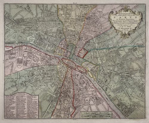
Title: NIEUWE KAART | der platte Grond van de Stad | PARYS | en derzelver Voorsteden. | Met aanwyzing van de Kwartieren, Staaten, | Markten, Pleinen, Paleizen, Abtyden, Kerken, | Kloosters en andere voornaame Gebouwen. | Na het Origineel van | M. DE LA GRIVE. | Te Amsterdam by | I. Tirion. | 1756. ||
Author : Jean Delagrive (French, 1689-1757)
Publisher: Isaak Tirion (Dutch, 1705 – 1765)
Publication date: 1756.
Dimensions: Sheet: 42.5 x 53.8 cm; Image: 30.7 x 37.7 cm.
Plate № 59 from Beknopte Atlas van omtrent honderd platte gronden der voornaamste vestingen, kasteelen en Steden van Europa. -
 Four maps 34 x 47.5 cm each. Include insets of Versailles, Fontainebleau, Saint Cloud and St. Germain en Laye. Lithograph by Edward Weller after a map drawn and engraved by John Dower. "These maps originally appeared in the Weekly Dispatch newspaper from 1856 to 1862. They were reissued between 1863 and 1867 by Cassell, Petter and Galpin and then published collectively as Cassell's Atlas. The plates were acquired by G.W. Bacon & Co., and reissued in 1876 under the title Bacon's New Quarto Atlas ... of the Counties of England, and many times since under various titles." [WorldCat]
Dimensions: 34 x 47.5 cm each.
Contributors: Weller, Edward (British, 1819 – 1884) – lithographer. Dower, John Crane (British, 1791 – 1847) – artist, engraver. Dower, John James (British, 1825 – 1901) – artist, engraver (son of John Crane Dower). -
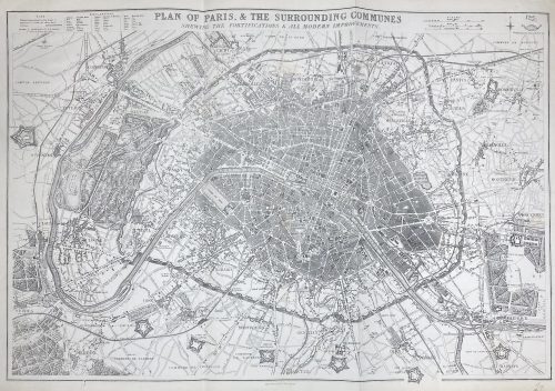 PLAN OF PARIS & THE SURROUNDING COMMUNES | SHEWING THE FORTIFICATIONS & ALL MODERN IMPROVEMENTS. || Lettered above the image with title, and below with production detail: "Day & Son, Lithrs to the Queen"; and production detail above: "Drawn & Engraved by B.R. Davies: / 16 George Str Euston Squ London", and on top right: "Weekly Dispatch Atlas, 138 Fleet Str". Dimensions: 47.5 x 65.4 cm. Contributors: Day & Son; William Day (British, 1797 – 1845) – lithographer, printer. Davies, Benjamin Rees (British, 1789 – 1872) – artist, engraver.
 -
-
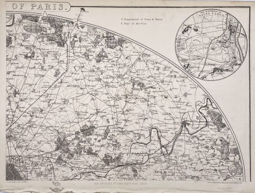
 Top: THE ENVIRONS OF PARIS. || Bottom centre: Published by Baldwin & Cradock, Paternoster Row, | Under the Superintendence of the Society for the Diffusion of Useful Knowledge. | March 1st. 1832. || Bottom right: J. & C. Walker sculpt. || Dimensions: Sheet: 34.7 x 40.5 cm; Image: 30 x 37 cm. Contributors: J & C Walker (British firm, fl. 1820 – 1895) Walker, John (British, 1787 – 1873) Walker, Alexander (British, 1797? – 1870) Walker, Charles (British, 1799? – 1872) Society for the Diffusion of Useful Knowledge (SDUK) (British firm, 1826 – 1846)
 -
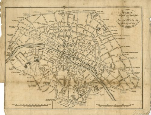
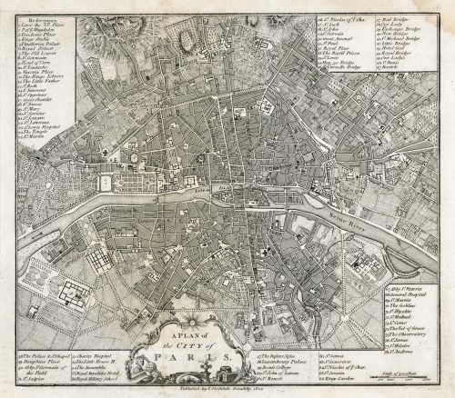 In pictorial frame: A PLAN of | the CITY of PARIS. || Under the border: Published by I. Stockdale Piccadilly 1800 || Dimensions: Sheet: 29 x 34.5 cm; Image: 22.7 x 25.9 cm.
 -
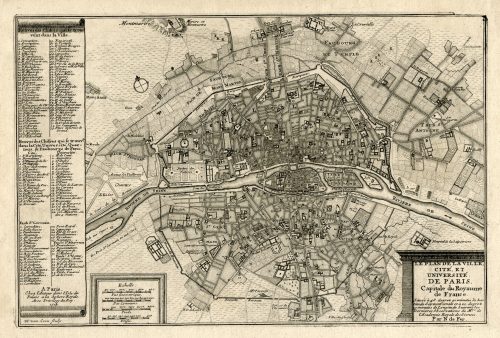 LE PLAN DE LA VILLE, | CITE, ET | UNIVERSITÉ | DE PARIS. | Capitale du Royaume | de France. | {5 lines in italic} | Par N. de Fer. | A Paris, | Chez l’Auteur dans l’Isle du | Palais a la Sphere Royale. | Avec Privilege du Roy. | 1705 | H. van Loon sculp. || Dimensions: Sheet: 27 x 39 cm; Image: 22 x 33 cm. Contributors: Nicolas de Fer (French, 1646 – 1720) – cartographer. Harmanus van Loon (Flemish, fl. c. 1690 – c. 1725) – engraver.
 -
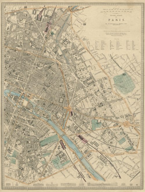 EASTERN DIVISION | OF | PARIS. | The Arrondissements are defined by colour | and numbered. || London, Edward Stanford 6 Charing Cross. | Published under the Superintendence of the Society for the Diffusion of Useful Knowledge. || Dimensions: Sheet: 43.5 x 35.5 cm; Image: 39.5 x 30 cm. Contributors: Edward Stanford (British, 1827 – 1904) – cartographer, engraver, publisher. Society for the Diffusion of Useful Knowledge (SDUK) (British firm, 1826 – 1846).
 -
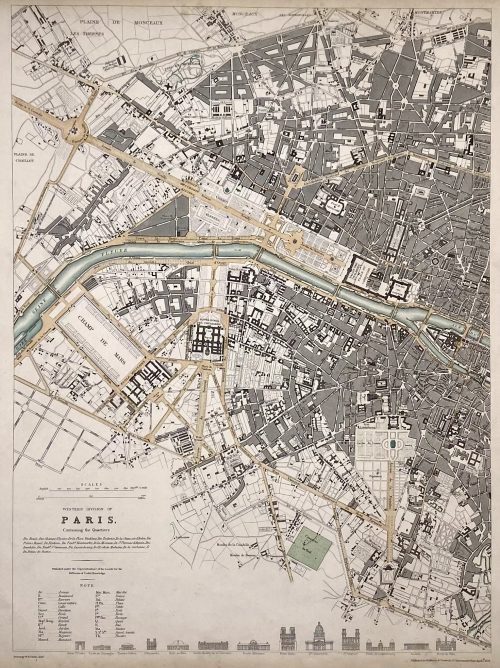 WESTERN DIVISION OF | PARIS. | Containing the Quartiers | {4 lines in italic} | Published under the Superintendence of the Society for the | Diffusion of Useful Knowledge || Under the frame: Drawn by W. B. Clarke, Archt. […] Published by Baldwin & Cradock, 47 Paternoster Row, April 1st. 1834. Dimensions: Sheet: 40.5 x 34.5 cm; Image: 39 x 28.8 cm. Contributors: William Barnard Clarke (British, 1806 – 1865) – artist. John Shury (fl. c. 1814-1844) – engraver. Baldwin & Cradock (London) – publisher. Society for the Diffusion of Useful Knowledge (SDUK) (British firm, 1826 – 1846).