

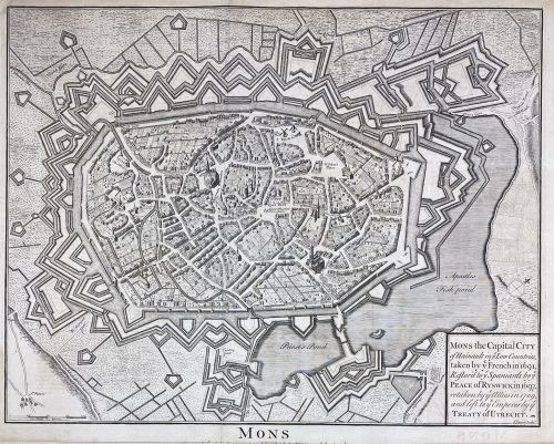
Mons the Capital City of Hainault in y Low Countries, taken by y French in 1691, Restor'd to y Spaniards by y Peace of Ryswick in 1697, retaken by y Allies in 1709, and left to y Emperor by y Treaty of Utrecht. attribution to publication source has been trimmed.
Dimensions: Sheet: 40.7 x 52.5 cm; Image: 37.5 x 48 cm. Published between 1744 and 1747. Attribution to publication source has been trimmed. Reference: Royal Academy 03/2919. Source: Maps for Mr. Tindal's Continuation of Mr. Rapin's History of England. London: John and Paul Knapton. Nicolas Tindal (British, 1687 – 1774) – the translator and continuer of the History of England by Paul de Rapin. Paul de Rapin (French, 1661 – 1725) – a Huguenot historian, author of the History of England.-
-
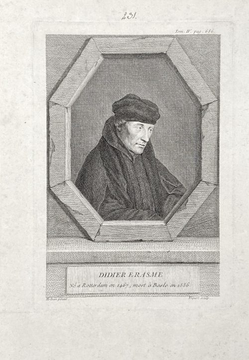 The portrait of Erasmus of Rotterdam (1466 – 1536), half-length, head to the right, body facing right, looking away, in a trompe-l'oeil octagonal frame. Inscriptions: Top right: Tom IV, pag. 686. Center of the image: DIDIER ERASME / Ne a Rotterdam en 1467, mort a Basle en 1536. Bottom of the plate: Holbein pinxit | Flipart Sculp. From the book Histoire générale des Provinces-Unies by Bénigne Dujardin (French, 1689 – 1771?) and Gottfried Sellius (real name Gottfried Sell) (1704? – 1767), published in 1757 in Paris by P. G. Simon. Volume 4, facing p. 686. Size: Sheet: 25 x 17.5 cm; Plate: 19.5 x 13.5 cm; Image: 18 x 12 cm. References: (1) Van Someren v.2, p.249, №1688; (2) https://archive.org/details/histoiregnra04duja/page/n714/mode/2up. Inscription above the plate: nut ink, hand, "231".
 -
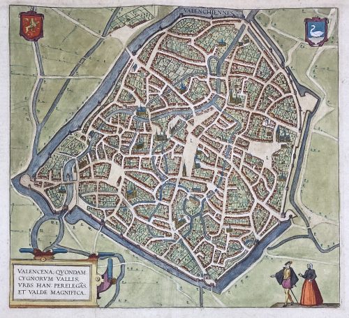 VALENCENA, QUONDAM | CYGNORUM VALLIS | URBS HAN: PERELEGÃS | ET VALDE MAGNIFICA. ||
Engraved and hand-coloured map of Valenciennes first produced for Braun & Hogenberg's 6-volume Civitates orbis terrarum edition in 1570.
English translation of the text printed on verso: "The Loire, an exceedingly well-known river in France, flows directly past the city and is very beneficial for trade. The fields surrounding the city are very fertile, and for this reason, the city is also called the granary throughout France, just as in earlier times Sicily was the granary of Rome. A famous wine also grows in this soil, which is exported from here not only throughout France but to all the countries in Europe. [...] The French spoken here is pure and uncorrupted, which is also the reason why so many foreigners settle here. For some are here for trade, others for study and others again to acquire the language, but also many without doubt for both these last two reasons, [...] and Germans, in particular, send their children here." [by Barry Lawrence Ruderman Antique Maps Inc.]
Dimensions: Sheet: 39.8 x 53.5 cm; Image: 35.2 x 38.5 cm.
Probably published in Cologne is 1612-18 by Petrum à Brachel: [Coloniae Agrippinae: apud Petrum à Brachel, sumptibus auctorum, 1612-1618]. Ref: LOC.Georg Braun [Brunus; Bruin] (German, 1541 – 1622).
Frans Hogenberg (Flemish-German, 1535 – 1590).
Abraham Ortelius [Ortels; Orthellius; Wortels] (Dutch, 1527 – 1598).
