-
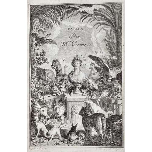 Title-page: FABLES | NOUVELLES. | {vignette by Ponce after Marillier} | A LA HAYE, | Et se trouve a Paris, | Chez Delalain, rue de la Comédie Françoise. | — | M. DCC. LXXIII. || Collation: 2 volumes (4 livres) in one, 1st blank, engraved t.p. “FABLES | Par | Mr. Dorat.” signed C. P. Marillier, inv. – E. D. Ghendt Sculp. 1772; a-c4, A-Z4 2A-2Q4, last blank, plus engraved frontispiece before A1 by Nicolas Delaunay and engraved d.t.p. before Z1: “Fables | de M. Dorat | II. Volume” also by Ghendt after Marillier., 99 vignettes and 99 tailpieces, all after Marillier. Lacking Delaunay frontispiece for the second volume (similar to the 1st). Edition: This is a vol. 1 176 pp. copy (Ray, 43). 2nd edition after Fables ou allégories philosophiques, 1772, p. 162 corrected: “Je sais , même au sein des poisons / Puiser le suc qui m'est utile”. Page xxii numbered correctly; on top of p. iii, printed a chain instead of a triple fillet in later issues (Ray, 43A). Pagination: [i, ii] iii-xxii, [2 d.t.p. «Livre premier»] [1] 2-309 [3 table], 3 plates. Binding: Crimson crashed morocco (198 x 133 mm) ruled in gilt, spine with raised bands gilt in compartments with gilt-lettered cream calf label, gilt dentelle inside, marbled endpapers, Pauli Menso bookplate pasted to front pastedown, printed on laid paper, AEG. Catalogue raisonné: Cohen-DeRicci: 313-315; Ray (French): № 43, pp. 81-83. Provenance: Pauli Menso. We only present a sample of illustrations, as their total number is enormous. Contributors: Author: Claude Joseph Dorat (French, 1734–1780) Publisher: Delalain (firm) (18th century) Artist: Clément Pierre Marillier (French, 1740–1808) Engravers: Jean Charles Baquoy (French, 1721–1777) Nicolas Delaunay (French, 1739–1792) Pierre Duflos (French, born in 1751) Emmanuel Jean Nepomucène de Ghendt (Flemish, worked in France, 1738–1815) Yves-Marie Le Gouaz (French, 1742–1816) Pierre Adrien Le Beau (French, 1748–after 1800) Jean-Jacques André Le Veau (French, 1729–1786) Charles Louis Lingée (French, 1748–1819) Joseph de Longueil (French, 1730–1792) Louis Legrand (French, 1723–1807) Jacques Le Roy (French, born in 1739) Louis Joseph Masquelier (French, 1741–1811) François Denis Née (French, 1735–1818) Nicholas Ponce (French, 1746–1831) Marguerite (Hémery) Ponce (French, born in 1745) Jean Baptiste Simonet (French, 1742–1813)
 -
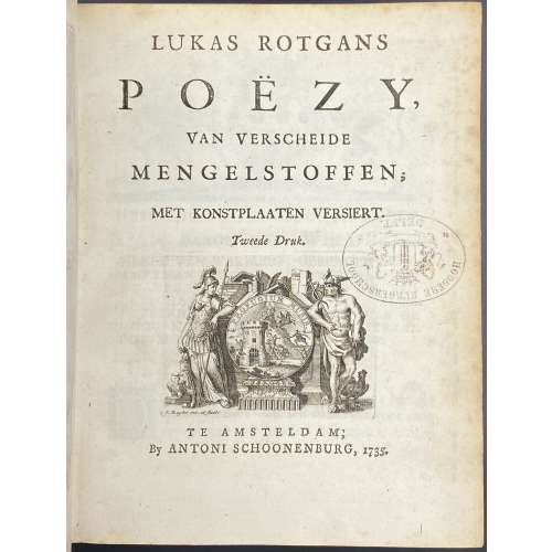 Title-page: LUKAS ROTGANS | POËZY, | VAN VERSCHEIDE | MENGELSTOFFEN; | MET KONSTPLAATEN VERSIERT. | Tweede Druk | {vignette} | TE AMSTERDAM; | By ANTONI SCHOONENBURG, 1735. || Collation: 4to; fep, 1st blank, engraved t.p. by M. Pool, t.p., *3,4; 2*-9*4, 10*1, *LII2, *LII, 10*2 —> *-10*4 (40 leaves); A-Z4, 2A-2Z4, 3A-3Z4, 4A-4Q4, last blank, fep; (340 leaves), 2 plates extraneous to collation. Pagination: [2] [1-5] 6-14 [15-80] [1-3] 4-680 [2], 2 unsigned plates not included in pagination after pp. 634 and 652, 50 headpieces by Jacob Folkema after Arnold Houbraken, and 2 tailpieces by Jan de Ruijter. Marks: Armorial bookplate: “Ex Libris J. J. Mak | {coat of arms} | Inveni Intermanere Melius”. Oval ink stamp: “HOOGERE BURGERSCHOOL. | DELFT” Provenance: Johannes Jacobus Mak (Dutch, 1908 – 1975). Edition: 2nd, 1st edition published in 1715 in Leeuwarden by François Halma. Contributors: Lukas Rotgans (Dutch, 1653 – 1710) – author. Arnold Houbraken (Dutch, 1660 – 1719) – artist. Jacob Folkema (Dutch, 1692 – 1767) – engraver. Matthijs Pool (Dutch, 1676 – 1740) – engraver. Jan de Ruijter (Dutch, 1688 – 1744) – engraver. Antoni Schoonenburg (Dutch, 1682 – 1754) – publisher.
 -
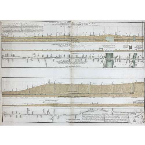
Two prints on one sheet of watermarked laid paper.
Coupe de la ville de Paris prise du septentrion au midy, depuis la porte St Martin jusqu'à l'Observatoire en passant par l'isle du Palais... Coupe de la ville de Paris depuis la porte St Martin jusqu'à l'Observatoire... Plan des rues comprises dans la direction dela coupe... / Le tout dressé par Philippe Buache... ; Desbruslins, sculpsit.
Watermark: "IHS" within circle; countermark of "FIN/ DUPUY/ AUVERGNE 1749".
LOC dates it to 1757. Gallica – to 1742, though the watermark is 1749.
-
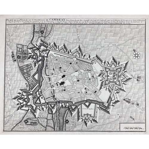
Plan de la ville et citadelle de Cambray : place forte du pays bas capitalle du Comté Cambresis situé sur la riviere de l'Escaut a trois lieues de Bouchain, a cinq du Quesnoy, a six et demy de Landrecy, a six de Valenciene, a cinq de Douay, a huit d'Arras, et a six de Perone, l'Archeveque de Cambray est Duc de Cambray, Comté du Cambresis et Prince du S. Empire, elle fut prix sur les espagnoles par Louis XIV, le 5.me d'April 1677; A AMSTERDAM Chez Covens & Mortier, Avec Privilege.
Date of publication: [between 1721 and 1778].
Dimensions: Sheet: 48 x 58.3 cm; Image: 38.2 x 47.7 cm. Earlier editions of the same were by Pierre Husson in the Hague (ca. 1715) and by Eugene Henry Fricx in Brussels (1710). -
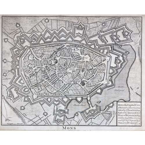
Mons the Capital City of Hainault in y Low Countries, taken by y French in 1691, Restor'd to y Spaniards by y Peace of Ryswick in 1697, retaken by y Allies in 1709, and left to y Emperor by y Treaty of Utrecht. attribution to publication source has been trimmed.
Dimensions: Sheet: 40.7 x 52.5 cm; Image: 37.5 x 48 cm. Published between 1744 and 1747. Attribution to publication source has been trimmed. Reference: Royal Academy 03/2919. Source: Maps for Mr. Tindal's Continuation of Mr. Rapin's History of England. London: John and Paul Knapton. Nicolas Tindal (British, 1687 – 1774) – the translator and continuer of the History of England by Paul de Rapin. Paul de Rapin (French, 1661 – 1725) – a Huguenot historian, author of the History of England. -
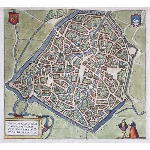 VALENCENA, QUONDAM | CYGNORUM VALLIS | URBS HAN: PERELEGÃS | ET VALDE MAGNIFICA. ||
Engraved and hand-coloured map of Valenciennes first produced for Braun & Hogenberg's 6-volume Civitates orbis terrarum edition in 1570.
English translation of the text printed on verso: "The Loire, an exceedingly well-known river in France, flows directly past the city and is very beneficial for trade. The fields surrounding the city are very fertile, and for this reason, the city is also called the granary throughout France, just as in earlier times Sicily was the granary of Rome. A famous wine also grows in this soil, which is exported from here not only throughout France but to all the countries in Europe. [...] The French spoken here is pure and uncorrupted, which is also the reason why so many foreigners settle here. For some are here for trade, others for study and others again to acquire the language, but also many without doubt for both these last two reasons, [...] and Germans, in particular, send their children here." [by Barry Lawrence Ruderman Antique Maps Inc.]
Dimensions: Sheet: 39.8 x 53.5 cm; Image: 35.2 x 38.5 cm.
Probably published in Cologne is 1612-18 by Petrum à Brachel: [Coloniae Agrippinae: apud Petrum à Brachel, sumptibus auctorum, 1612-1618]. Ref: LOC.Georg Braun [Brunus; Bruin] (German, 1541 – 1622).
Frans Hogenberg (Flemish-German, 1535 – 1590).
Abraham Ortelius [Ortels; Orthellius; Wortels] (Dutch, 1527 – 1598). -
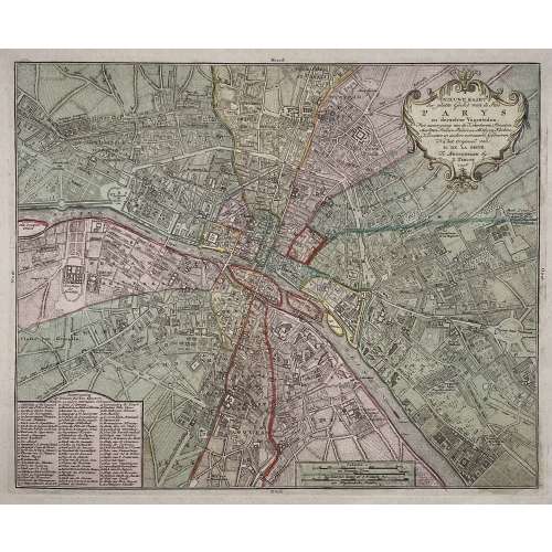
Title: NIEUWE KAART | der platte Grond van de Stad | PARYS | en derzelver Voorsteden. | Met aanwyzing van de Kwartieren, Staaten, | Markten, Pleinen, Paleizen, Abtyden, Kerken, | Kloosters en andere voornaame Gebouwen. | Na het Origineel van | M. DE LA GRIVE. | Te Amsterdam by | I. Tirion. | 1756. ||
Author : Jean Delagrive (French, 1689-1757)
Publisher: Isaak Tirion (Dutch, 1705 – 1765)
Publication date: 1756.
Dimensions: Sheet: 42.5 x 53.8 cm; Image: 30.7 x 37.7 cm.
Plate № 59 from Beknopte Atlas van omtrent honderd platte gronden der voornaamste vestingen, kasteelen en Steden van Europa. -
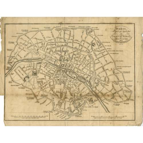 Title: PARIS | Tel qu'il est Aujourd'hui | OR | PLAN OF PARIS | At the Present day. 1800 | From a Drawing deposited in the Archieves of the National Library at Paris | Menzies sculpt. || Contributor: Menzies, John (British, fl. c. 1792 – 1851) – engraver. Ref: Gallica.
 -
 Top: THE ENVIRONS OF PARIS. || Bottom centre: Published by Baldwin & Cradock, Paternoster Row, | Under the Superintendence of the Society for the Diffusion of Useful Knowledge. | March 1st. 1832. || Bottom right: J. & C. Walker sculpt. || Dimensions: Sheet: 34.7 x 40.5 cm; Image: 30 x 37 cm. Contributors: J & C Walker (British firm, fl. 1820 – 1895) Walker, John (British, 1787 – 1873) Walker, Alexander (British, 1797? – 1870) Walker, Charles (British, 1799? – 1872) Society for the Diffusion of Useful Knowledge (SDUK) (British firm, 1826 – 1846)
 -
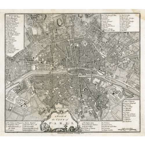 In pictorial frame: A PLAN of | the CITY of PARIS. || Under the border: Published by I. Stockdale Piccadilly 1800 || Dimensions: Sheet: 29 x 34.5 cm; Image: 22.7 x 25.9 cm.
 -
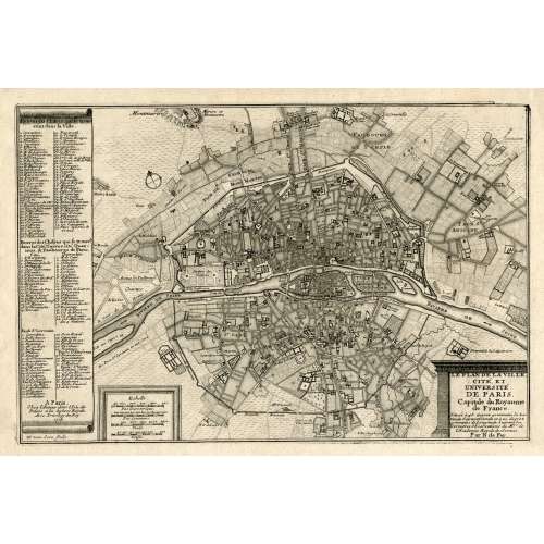 LE PLAN DE LA VILLE, | CITE, ET | UNIVERSITÉ | DE PARIS. | Capitale du Royaume | de France. | {5 lines in italic} | Par N. de Fer. | A Paris, | Chez l’Auteur dans l’Isle du | Palais a la Sphere Royale. | Avec Privilege du Roy. | 1705 | H. van Loon sculp. || Dimensions: Sheet: 27 x 39 cm; Image: 22 x 33 cm. Contributors: Nicolas de Fer (French, 1646 – 1720) – cartographer. Harmanus van Loon (Flemish, fl. c. 1690 – c. 1725) – engraver.
 -
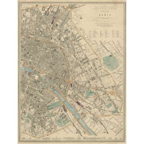 EASTERN DIVISION | OF | PARIS. | The Arrondissements are defined by colour | and numbered. || London, Edward Stanford 6 Charing Cross. | Published under the Superintendence of the Society for the Diffusion of Useful Knowledge. || Dimensions: Sheet: 43.5 x 35.5 cm; Image: 39.5 x 30 cm. Contributors: Edward Stanford (British, 1827 – 1904) – cartographer, engraver, publisher. Society for the Diffusion of Useful Knowledge (SDUK) (British firm, 1826 – 1846).
 -
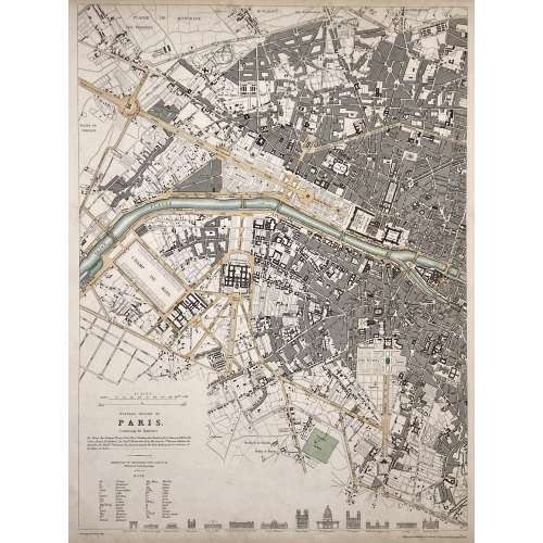 WESTERN DIVISION OF | PARIS. | Containing the Quartiers | {4 lines in italic} | Published under the Superintendence of the Society for the | Diffusion of Useful Knowledge || Under the frame: Drawn by W. B. Clarke, Archt. […] Published by Baldwin & Cradock, 47 Paternoster Row, April 1st. 1834. Dimensions: Sheet: 40.5 x 34.5 cm; Image: 39 x 28.8 cm. Contributors: William Barnard Clarke (British, 1806 – 1865) – artist. John Shury (fl. c. 1814-1844) – engraver. Baldwin & Cradock (London) – publisher. Society for the Diffusion of Useful Knowledge (SDUK) (British firm, 1826 – 1846).
 -
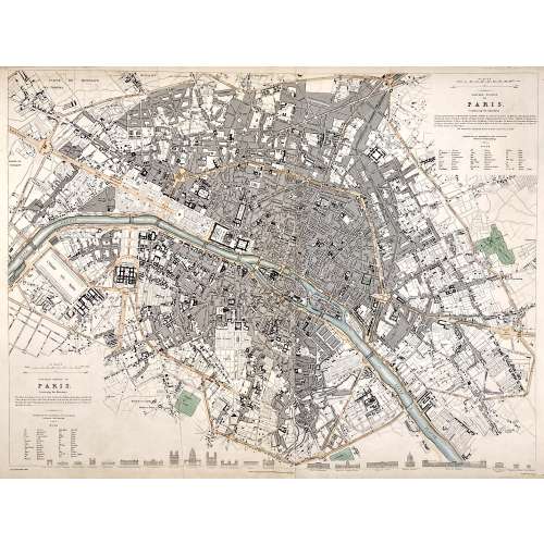 Top right: EASTERN DIVISION OF | PARIS. | Containing the Quartiers | {5 lines in italic} | Published under the Superintendence of the Society for the | Diffusion of Useful Knowledge || Bottom left: WESTERN DIVISION OF | PARIS. | Containing the Quartiers | {4 lines in italic} | Published under the Superintendence of the Society for the | Diffusion of Useful Knowledge || Under the frame: Drawn by W. B. Clarke, Archt. […] London: Published by Chapman and Hall, 186, Strand. April 1st, 1834. [...] Engraved by J. Shury || Dimensions: Sheet: 40.8 x 57 cm; Image: 38.7 x 52.5 cm. Contributors: William Barnard Clarke (British, 1806 – 1865) – artist. John Shury (fl. c. 1814-1844) – engraver. Chapman and Hall (London) – publisher. Society for the Diffusion of Useful Knowledge (SDUK) (British firm, 1826 – 1846).
 -
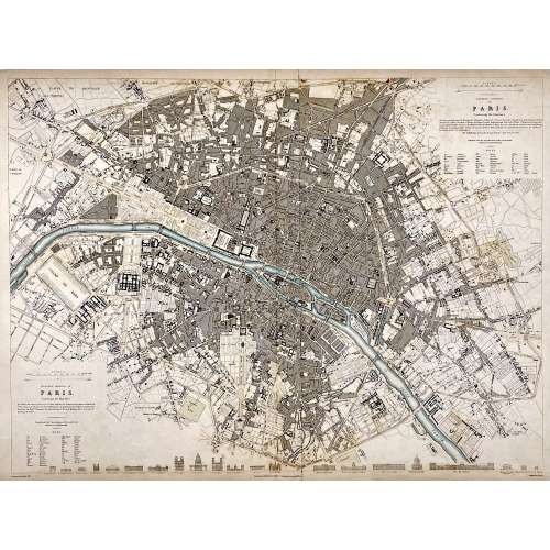 Top right: EASTERN DIVISION OF | PARIS. | Containing the Quartiers | {5 lines in italic} | Published under the Superintendence of the Society for the | Diffusion of Useful Knowledge || Bottom left: WESTERN DIVISION OF | PARIS. | Containing the Quartiers | {4 lines in italic} | Published under the Superintendence of the Society for the | Diffusion of Useful Knowledge || Under the frame: Drawn by W. B. Clarke, Archt. […] Published by Baldwin & Cradock, 47 Paternoster Row, A April 1st, 1834. [...] Engraved by J. Shury || Dimensions: Sheet: 40.8 x 57 cm; Image: 38.7 x 52.5 cm. Contributors: William Barnard Clarke (British, 1806 – 1865) – artist. John Shury (fl. c. 1814-1844) – engraver. Baldwin & Cradock (London) – publisher. Society for the Diffusion of Useful Knowledge (SDUK) (British firm, 1826 – 1846).
 -
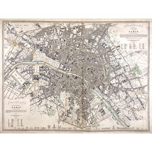 Top right: EASTERN DIVISION OF | PARIS. | Containing the Quartiers | {5 lines in italic} | Published under the Superintendence of the Society for the | Diffusion of Useful Knowledge || Bottom left: WESTERN DIVISION OF | PARIS. | Containing the Quartiers | {4 lines in italic} | Published under the Superintendence of the Society for the | Diffusion of Useful Knowledge || The map is framed, but there is no lettering beneath the frame to identify the cartographer, engraver, and publisher. However, we can attribute it to William Barnard Clarke (British, 1806 – 1865) and John Shury (fl. c. 1814-1844). The publisher is either Baldwin & Cradock or Chapman and Hall. Dimensions: Sheet: 40 x 60.8 cm; Image: 40 x 53.5 cm.
 -
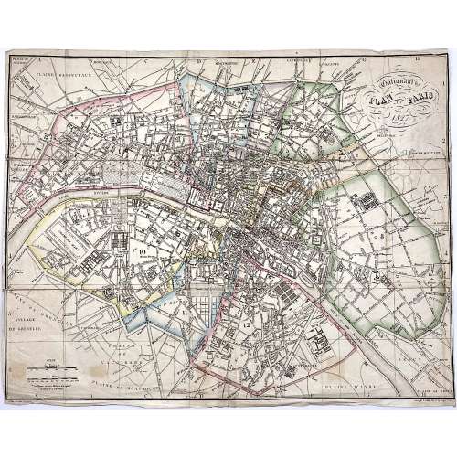 Upper right: Galignani's | PLAN OF PARIS | 1827 || in oval frame: Sauve sculpt. Bottom, under the frame: le Plan écrit par Lallemand. […] Gravé par E. Collin. Rue de la Harpe № 45. Dimensions: 36.5 x 46.5 cm. Armand Joseph Lallemand (French, c. 1810 - 1871) – cartographer. Charles-Étienne Collin (French, 1770 – 1840) – engraver. Étienne Collin II (French,1790 – 1852) – engraver. John Anthony Galignani (Italian, 1796 – 1873) – publisher. William Galignani (Italian, 1798 – 1882) – publisher.
 -
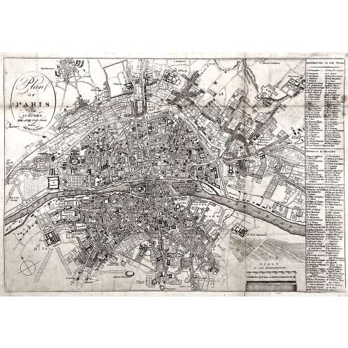 Oval cartouche in the upper-left corner, with tall “s”: Plan | OF | PARIS | and | SUBURBS | With all the Cross Streets | Before | THE REVOLUTION. || No indication of the makers. Dimensions: Sheet: 32.5 x 44.3 cm; Image: 28.5 x 41.3 cm.


