-
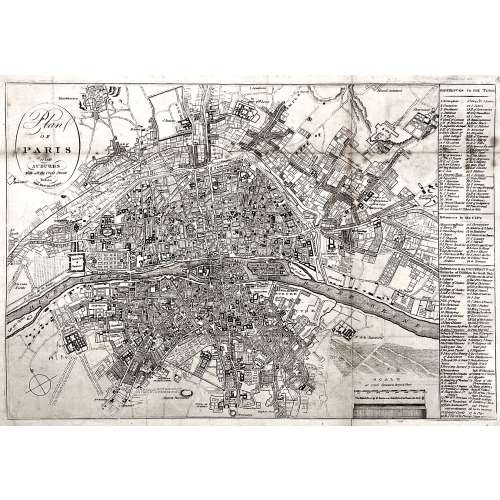 Oval cartouche in the upper-left corner, with tall “s”: Plan | OF | PARIS | and | SUBURBS | With all the Cross Streets | Before | THE REVOLUTION. || No indication of the makers. Dimensions: Sheet: 32.5 x 44.3 cm; Image: 28.5 x 41.3 cm.
 -
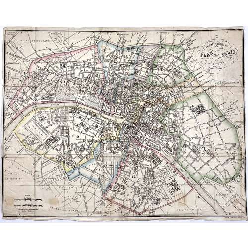 Upper right: Galignani's | PLAN OF PARIS | 1827 || in oval frame: Sauve sculpt. Bottom, under the frame: le Plan écrit par Lallemand. […] Gravé par E. Collin. Rue de la Harpe № 45. Dimensions: 36.5 x 46.5 cm. Armand Joseph Lallemand (French, c. 1810 - 1871) – cartographer. Charles-Étienne Collin (French, 1770 – 1840) – engraver. Étienne Collin II (French,1790 – 1852) – engraver. John Anthony Galignani (Italian, 1796 – 1873) – publisher. William Galignani (Italian, 1798 – 1882) – publisher.
 -
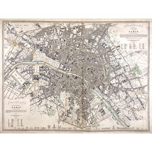 Top right: EASTERN DIVISION OF | PARIS. | Containing the Quartiers | {5 lines in italic} | Published under the Superintendence of the Society for the | Diffusion of Useful Knowledge || Bottom left: WESTERN DIVISION OF | PARIS. | Containing the Quartiers | {4 lines in italic} | Published under the Superintendence of the Society for the | Diffusion of Useful Knowledge || The map is framed, but there is no lettering beneath the frame to identify the cartographer, engraver, and publisher. However, we can attribute it to William Barnard Clarke (British, 1806 – 1865) and John Shury (fl. c. 1814-1844). The publisher is either Baldwin & Cradock or Chapman and Hall. Dimensions: Sheet: 40 x 60.8 cm; Image: 40 x 53.5 cm.
 -
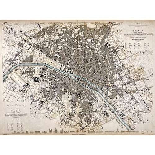 Top right: EASTERN DIVISION OF | PARIS. | Containing the Quartiers | {5 lines in italic} | Published under the Superintendence of the Society for the | Diffusion of Useful Knowledge || Bottom left: WESTERN DIVISION OF | PARIS. | Containing the Quartiers | {4 lines in italic} | Published under the Superintendence of the Society for the | Diffusion of Useful Knowledge || Under the frame: Drawn by W. B. Clarke, Archt. […] Published by Baldwin & Cradock, 47 Paternoster Row, A April 1st, 1834. [...] Engraved by J. Shury || Dimensions: Sheet: 40.8 x 57 cm; Image: 38.7 x 52.5 cm. Contributors: William Barnard Clarke (British, 1806 – 1865) – artist. John Shury (fl. c. 1814-1844) – engraver. Baldwin & Cradock (London) – publisher. Society for the Diffusion of Useful Knowledge (SDUK) (British firm, 1826 – 1846).
 -
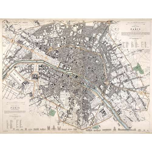 Top right: EASTERN DIVISION OF | PARIS. | Containing the Quartiers | {5 lines in italic} | Published under the Superintendence of the Society for the | Diffusion of Useful Knowledge || Bottom left: WESTERN DIVISION OF | PARIS. | Containing the Quartiers | {4 lines in italic} | Published under the Superintendence of the Society for the | Diffusion of Useful Knowledge || Under the frame: Drawn by W. B. Clarke, Archt. […] London: Published by Chapman and Hall, 186, Strand. April 1st, 1834. [...] Engraved by J. Shury || Dimensions: Sheet: 40.8 x 57 cm; Image: 38.7 x 52.5 cm. Contributors: William Barnard Clarke (British, 1806 – 1865) – artist. John Shury (fl. c. 1814-1844) – engraver. Chapman and Hall (London) – publisher. Society for the Diffusion of Useful Knowledge (SDUK) (British firm, 1826 – 1846).
 -
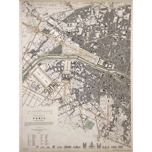 WESTERN DIVISION OF | PARIS. | Containing the Quartiers | {4 lines in italic} | Published under the Superintendence of the Society for the | Diffusion of Useful Knowledge || Under the frame: Drawn by W. B. Clarke, Archt. […] Published by Baldwin & Cradock, 47 Paternoster Row, April 1st. 1834. Dimensions: Sheet: 40.5 x 34.5 cm; Image: 39 x 28.8 cm. Contributors: William Barnard Clarke (British, 1806 – 1865) – artist. John Shury (fl. c. 1814-1844) – engraver. Baldwin & Cradock (London) – publisher. Society for the Diffusion of Useful Knowledge (SDUK) (British firm, 1826 – 1846).
 -
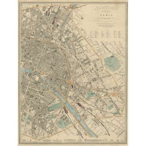 EASTERN DIVISION | OF | PARIS. | The Arrondissements are defined by colour | and numbered. || London, Edward Stanford 6 Charing Cross. | Published under the Superintendence of the Society for the Diffusion of Useful Knowledge. || Dimensions: Sheet: 43.5 x 35.5 cm; Image: 39.5 x 30 cm. Contributors: Edward Stanford (British, 1827 – 1904) – cartographer, engraver, publisher. Society for the Diffusion of Useful Knowledge (SDUK) (British firm, 1826 – 1846).
 -
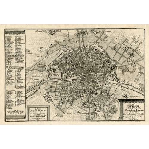 LE PLAN DE LA VILLE, | CITE, ET | UNIVERSITÉ | DE PARIS. | Capitale du Royaume | de France. | {5 lines in italic} | Par N. de Fer. | A Paris, | Chez l’Auteur dans l’Isle du | Palais a la Sphere Royale. | Avec Privilege du Roy. | 1705 | H. van Loon sculp. || Dimensions: Sheet: 27 x 39 cm; Image: 22 x 33 cm. Contributors: Nicolas de Fer (French, 1646 – 1720) – cartographer. Harmanus van Loon (Flemish, fl. c. 1690 – c. 1725) – engraver.
 -
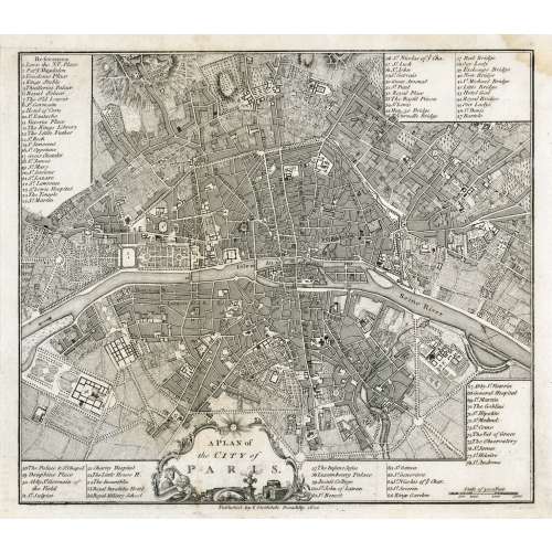 In pictorial frame: A PLAN of | the CITY of PARIS. || Under the border: Published by I. Stockdale Piccadilly 1800 || Dimensions: Sheet: 29 x 34.5 cm; Image: 22.7 x 25.9 cm.
 -
 Top: THE ENVIRONS OF PARIS. || Bottom centre: Published by Baldwin & Cradock, Paternoster Row, | Under the Superintendence of the Society for the Diffusion of Useful Knowledge. | March 1st. 1832. || Bottom right: J. & C. Walker sculpt. || Dimensions: Sheet: 34.7 x 40.5 cm; Image: 30 x 37 cm. Contributors: J & C Walker (British firm, fl. 1820 – 1895) Walker, John (British, 1787 – 1873) Walker, Alexander (British, 1797? – 1870) Walker, Charles (British, 1799? – 1872) Society for the Diffusion of Useful Knowledge (SDUK) (British firm, 1826 – 1846)
 -
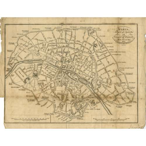 Title: PARIS | Tel qu'il est Aujourd'hui | OR | PLAN OF PARIS | At the Present day. 1800 | From a Drawing deposited in the Archieves of the National Library at Paris | Menzies sculpt. || Contributor: Menzies, John (British, fl. c. 1792 – 1851) – engraver. Ref: Gallica.
 -
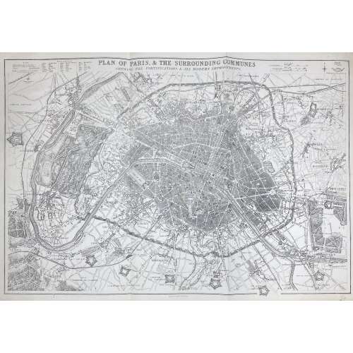 PLAN OF PARIS & THE SURROUNDING COMMUNES | SHEWING THE FORTIFICATIONS & ALL MODERN IMPROVEMENTS. || Lettered above the image with title, and below with production detail: "Day & Son, Lithrs to the Queen"; and production detail above: "Drawn & Engraved by B.R. Davies: / 16 George Str Euston Squ London", and on top right: "Weekly Dispatch Atlas, 138 Fleet Str". Dimensions: 47.5 x 65.4 cm. Contributors: Day & Son; William Day (British, 1797 – 1845) – lithographer, printer. Davies, Benjamin Rees (British, 1789 – 1872) – artist, engraver.
 -
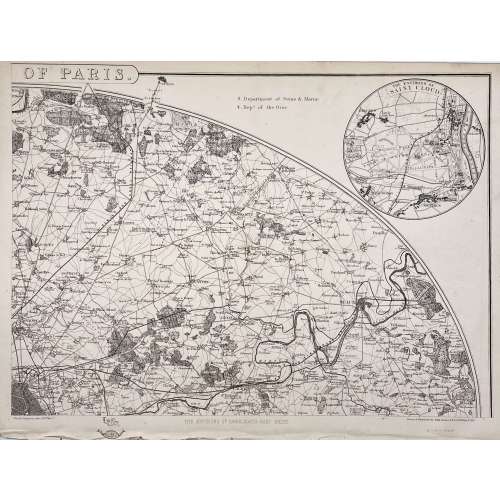 Four maps 34 x 47.5 cm each. Include insets of Versailles, Fontainebleau, Saint Cloud and St. Germain en Laye. Lithograph by Edward Weller after a map drawn and engraved by John Dower. "These maps originally appeared in the Weekly Dispatch newspaper from 1856 to 1862. They were reissued between 1863 and 1867 by Cassell, Petter and Galpin and then published collectively as Cassell's Atlas. The plates were acquired by G.W. Bacon & Co., and reissued in 1876 under the title Bacon's New Quarto Atlas ... of the Counties of England, and many times since under various titles." [WorldCat]
Dimensions: 34 x 47.5 cm each.
Contributors: Weller, Edward (British, 1819 – 1884) – lithographer. Dower, John Crane (British, 1791 – 1847) – artist, engraver. Dower, John James (British, 1825 – 1901) – artist, engraver (son of John Crane Dower). -
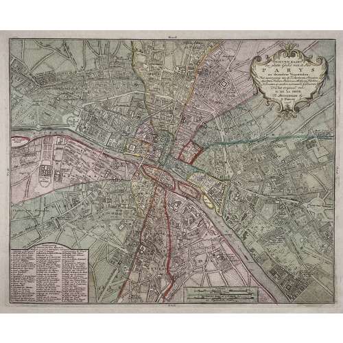
Title: NIEUWE KAART | der platte Grond van de Stad | PARYS | en derzelver Voorsteden. | Met aanwyzing van de Kwartieren, Staaten, | Markten, Pleinen, Paleizen, Abtyden, Kerken, | Kloosters en andere voornaame Gebouwen. | Na het Origineel van | M. DE LA GRIVE. | Te Amsterdam by | I. Tirion. | 1756. ||
Author : Jean Delagrive (French, 1689-1757)
Publisher: Isaak Tirion (Dutch, 1705 – 1765)
Publication date: 1756.
Dimensions: Sheet: 42.5 x 53.8 cm; Image: 30.7 x 37.7 cm.
Plate № 59 from Beknopte Atlas van omtrent honderd platte gronden der voornaamste vestingen, kasteelen en Steden van Europa. -
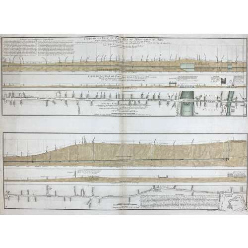
Two prints on one sheet of watermarked laid paper.
Coupe de la ville de Paris prise du septentrion au midy, depuis la porte St Martin jusqu'à l'Observatoire en passant par l'isle du Palais... Coupe de la ville de Paris depuis la porte St Martin jusqu'à l'Observatoire... Plan des rues comprises dans la direction dela coupe... / Le tout dressé par Philippe Buache... ; Desbruslins, sculpsit.
Watermark: "IHS" within circle; countermark of "FIN/ DUPUY/ AUVERGNE 1749".
LOC dates it to 1757. Gallica – to 1742, though the watermark is 1749.
-

Lithography on paper by Charles Fichot (French, 1817 – 1903), published in a supplement to the Illustrated London News of July 6, 1867.
The construction on the foreground is the International Exposition of 1867 (Exposition universelle d'art et d'industrie de 1867). Dimensions: Sheet: 130 x 58 cm; Image: 118 x 43 cm. -
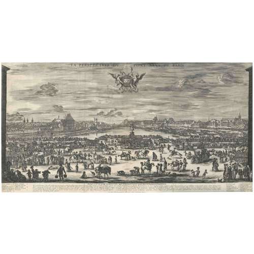
Etching on laid paper, backed. Massar (1971): 59-61. View of the Pont Neuf in Paris, with the statue of Henry IV at centre in front of the Seine, the church of St.-Germaine l'Auxerrois and the Louvre to the right, and the Hôtel de Nevers and Tour de Nesle to the left (MET). in the banner below: LUDOVICO XIIII GALLIARUM ET NAV REGI; below image: PONS LVTETIÆ STRVCTVS, DICTVS NOVVS, ET QVÆ EX EO PROSPICI POSSVNT.; bellow: En pulcherrimus toto ... caufatus, vifere; along the bottom: Ste. Della Bella Florentinus In. e Fecit DD. 1646. Cum Privilegio Regis; additional lettering a lower left and right identifying places depicted.
State: 2nd, with the weathercock on the belltower of Église Saint-Germain l'Auxerrois (under 8). Size: 35.5 x 67.6 cm. Condition: Three vertical folds, these partly cracked and backed at the bottom, dusty or slightly stained, partly slightly rubbed, a small diagonal crease on the upper left, tiny marginal blemishes.Quotation from Phyllis D. Massar. Presenting Stefano della Bella. — NY: The Metropolitan Museum of Art, [1971]: "For size and complexity, one of Della Bella's most impressive achievements is his view of Paris across the Pont Neuf from a point between the buildings bounding the Place Dauphine. Besides the well-known landmarks-the Hộtel de Nevers, the Tour de Nesle, the church of Saint Germain l'Auxerrois, and, at the centre, the bronze equestrian statue of Henri IV by the Florentines Giovanni Bologna and Pietro Tacca – the print provides a microcosm of Paris in transit across the Seine. With a glass, one can compile a census of 451 people, thirty-eight horses, nineteen dogs, three donkeys, and one lamb. All but lost in the vast scene, nevertheless, all contributing to it, are duelists, men fighting with staffs, brawlers routing passers-by, a tooth-puller making an extraction, sellers of sweetmeats and fruits, falconers, hunters with a pack of dogs, a legless cripple, many begging gypsies (one of them telling a fortune), and a hurdy-gurdy player with an audience. Moving among the splendid carriages is a humble water cart, and back among the market stands at the right is an early Seine-side bookstall."
Catalogue raisonné: Massar (1971): pp. 58-61; De Vesme p. 132, № 850ii/ii. Contributor: Stefano della Bella (Italian, 1610 – 1664) – artist and engraver. -
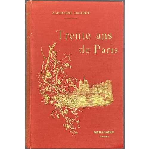 Pictorial title (coloured): Collection Artistique Guillaume et Cie |—| ALPHONSE DAUDET | Trente ans | de Paris | PARIS | C. MARPON ET E. FLAMMARION | 26, RUE RACINE, 26 | 1888 || Title page: Collection Artistique Guillaume et Cie |—| ALPHONSE DAUDET | Trente ans de Paris | À TRAVERS MA VIE ET MES LIVRES | Illustré | PAR BIELER, MONTÉGUT, MYRBACH, PICARD ET ROSSI | Gravure de Guillaume Frères et Cie | PARIS | C. MARPON ET E. FLAMMARION | 26, RUE RACINE, 26 | 1888 | Tous droits réservés. || Pagination: [12] [1] 2-344 [6], total 362 pp., in-text illustration, head- and tailpieces, photomechanical reproductions. Collation: 12mo; π6, 1-2812 +1; total 181 leaves. Binding: 19 x 12.5 cm; red cloth, gilt lettering to spine, gilt lettering and vignette to front board and gilt device to back board; bookplate to front pastedown: Ex Libris Dr. Vodoz = Egg; Gift inscription to flyleaf in German, dated 30/12/87. Contributors: Alphonse Daudet (French, 1840 – 1897) – author. Ernest Biéler (Swiss, 1863 – 1948) – artist. Louis Montégut (French, 1855 – 1906) – artist. Felician Myrbach (Austrian, 1853 – 1940) – artist. Georges Picard (French, 1857 – 1943) – artist. Luigi Rossi (Swiss, 1853 – 1923) – artist. Ernest Flammarion (French, 1846 – 1936) – publisher. Charles Marpon (French, 1838 – 1890) – publisher. Alexis Lahure (French, 1849 – 1928) – printer. Guillaume Frères et Cie – engravers.


